Visiting South Mountain Battlefield
Posted By Jake Wynn on June 29, 2013
South Mountain State Battlefield, a half hour drive from both Hagerstown and Frederick, should be a stop for any Civil War historian or novice. Located about 30 minutes away from both Frederick and Hagerstown, its a great place for combining hiking and history.
Washington Monument State Park:
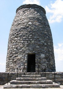
Originally constructed in the early half of the 19th century, the Washington Monument (not to be confused with one in D.C.) rises 30 feet above the surrounding mountain side. Constructed to honor the late George Washington, the unique stone monument stood during the time of the Civil War and was used as a Union signal station. Following the war, the site twice crumbled and was repaired. It was restored to its present state by the Civilian Conservation Corps during the Great Depression. The site is now on the National Register of Historic Places and resides within Washington Monument State Park.
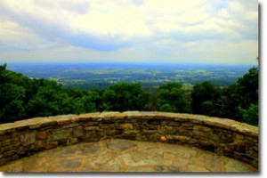
The view from atop the monument is fabulous, and one can easily see why the spot would have been picked by Union engineers. It gives a commanding view of the surrounding countryside. From this perch, you can see over the entire Antietam battlefield, Hagerstown and even into Pennsylvania. Its a view that is worth the small hike to the summit.
The main office for the South Mountain State Battlefield is on the grounds, as well as the park’s museum that holds artifacts from both the monument and the battle. From the park’s website:
Museum
The monument museum features historical artifacts related to the history of Washington Monument and the Battle of South Mountain. It is open on weekends only in April and October, and seven days a week from May through September. It is closed during the winter.
The address of the park is 6620 Zittlestown Road, Middletown, MD 21769. Complete directions can be found on the park’s website. The park is well marked on Route 40 (The National Road Scenic Byway) between the towns of Middletown and Boonsboro.
Fox’s Gap is located about a mile south of Route 40, along what is now called Reno Monument Road. Arriving at this section of the battlefield, you will see a few fields and monuments. Signs direct you to a small parking lot; this is within walking distance of much of the battlefield and was once home to the Wise homestead. Much of the battle was fought on this family’s land, and at the end of the battle, dozens of Southern bodies were dumped into their well.
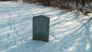
Two monuments mark the area immediately around the parking lot. One resembles a small grave marker.
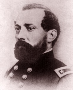
Near here in Wise’s field on the morning of Sept. 14, 2862. Brigadier General Samuel Garland, Jr. C.S.A. of Lynchburg, Virginia fell mortally wounded while leading his men.
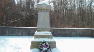
Only a few yards away, behind a concrete wall lies a memorial to another prominent general felled by gunfire during the battle for Fox’s Gap, IX Corps Commander, General Jesse Reno. For such a small (by Civil War standards) engagement, the loss of two major leaders within such a small geographical location is curious. It says something about the nature of the fighting that Sunday in September 1862.
On the other side of the road lies the field across which the 17th Michigan made its heroic and deadly charge in the afternoon of the battle. Behind the stone wall, the Appalachian Trail scrambles through the rocks and trees where men in blue and butternut once mingled in a haze of battle smoke. The trail can be followed to the north and comes out a mile north at Route 40 in Turner’s Gap.
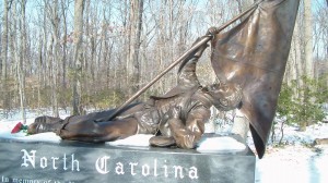
But the most identifiable of the monuments belongs to the men from North Carolina. The polished black stone monument depicts a fallen North Carolinian, cast in bronze, clutching a shredded battle flag. Inscribed with the Confederate creed, “Deo Vindice,” or “With God as our Defender,” the monument is the most striking on the battlefield and can be viewed by either walking the road or the General Garland trail.
Fox’s Gap is a must see for anyone interested in the Civil War and with links to the Lykens Valley area. Many soldiers from the area took part in the struggle at Fox’s Gap. The next stop was possibly the most bloody struggle of the South Mountain battles, at least for the men of the 96th Pennsylvania…
Crampton’s Gap
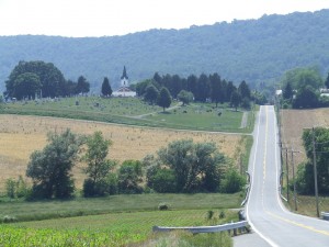
This section of the South Mountain Battlefield is separated from the rest of the park by several miles. Located near the village of Burkittsville, the mountain looms very large over this small, historic village of 150 people. A small mountain road links the Middletown Valley from Pleasant Valley on the other side. A struggle here would prove to be one of the bloodiest of the day. The VI Corps charged up this steep slope under heavy fire. I will more fully cover the tale of the 96th Pennsylvania’s role in the battle in a few weeks time.
The village of Burkittsville should be the first stop on your tour. The small hamlet has cobblestone streets and many historic structures dating to the Civil War remain. Wounded men from both sides were initially treated in the churches of the town before being transferred elsewhere.
Between the town and the mountain is where much of the battle took place. As most of this land has not been preserved or is private property, you will need to climb up into Crampton’s Gap itself for the next segment of your visit,
Gathland State Park lies at the crest of the hill. The area was the crescendo of battle at Crampton’s Gap, which saw the final collapse of the Confederate defense of the pass. It later became the estate of Civil War correspondent and novelist George Alfred Townsend. In the gap he constructed his home, including many buildings and the park’s marquee feature today.
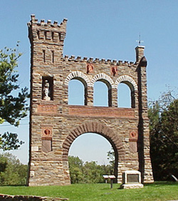
The War Correspondent’s Arch is a 50 foot high memorial to the reporter’s of the Civil War. Completed in 1896, it is now administered by the National Park Service, even though it lies on ground owned by the state of Maryland.
Gathland State Park has many placards and interpretive markers disseminating information about the battle. It is a great spot to stop on your trek through the battles of South Mountain!
While much of your focus may naturally head towards Antietam, only a few miles away, a visit to South Mountain can complete your trek through the Maryland Campaign. The stories here are compelling, and if you have Civil War ancestors from the Lykens Valley, it may just be chance to connect with one of their lesser known struggles of the Civil War.
 ;
;


Great post, Jake. Of course, a great first stop on the way to South Mountain is the Frederick Visitor Center, 151 South East Street in Frederick. The staff can provide directions, maps and other helpful suggestions for your time in Frederick County.
My Grandfather Philemon Henry McCracken was in the battle of South Mountain he was wounded by gunshot to the knee. And he was treated and placed in charge of a wagon group. He was promoted to the rank of Sgt for his duties. According to his military records he continued to serve. And he was discharged at Delaney house DC at the close of the war.