Oak Dale Station and the Civil War
Posted By Norman Gasbarro on December 8, 2010
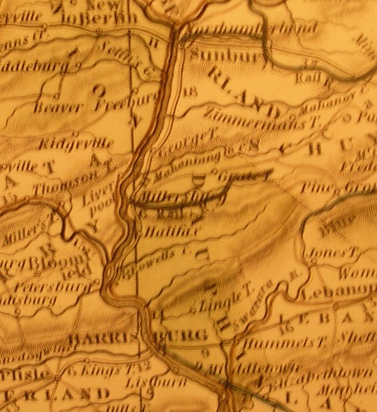
During the Civil War, one railroad ran from the interior of the Lykens Valley area to the Susquehanna River. Believed to be completed in 1834, the line went from Millersburg to Lykens. Its primary use was to transport coal from the coal mines around Lykens to the Susquehanna River. Horses pulled the early coal cars to a point near Elizabethville where the cars were released and they traveled by gravity to Millersburg. The coal cars were then loaded on boats for further journey to their destinations, some down river as far as Clark’s Ferry by the newly-built Wiconisco Canal which ran from Millersburg to Clark’s Ferry. Unfortunately, this early rail line used a flat strap iron rail which resulted in frequent accidents and derailments.
Around 1856, the line was taken over by the Pennsylvania Railroad Company and the track was replaced by the more durable and safer T-rail. Also around this time, the Northern Central Railroad completed a new line from Dauphin (north of Harrisburg) up the eastern side of the Susquehanna to Millersburg, which enabled the coal cars to avoid the water journey.
At first these rail lines were used exclusively for freight service, mainly coal transport, but as the Civil War approached, both the rail companies and the residents of the Lykens Valley area recognized that they also could be used for passenger service. Courtesy cars for passengers were run on most trips so that passengers could board at stops along the route and travel in somewhat comfort to Millersburg and thence to the county seat and state capital, Harrisburg. At the Harrisburg station, connections could be made for Philadelphia or points south such as Baltimore and Washington, D.C.
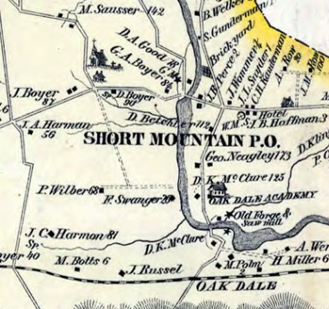
Heading west from Lykens, the train first stopped at Oak Dale (once also called Short Mountain Post Office, but now called Loyalton), a community very close to the end of Short Mountain. On the eastern side of Oak Dale and on the south side of Short Mountain were the collieries. At the main intersection in the village, where the Crossroads meets Route 209 today, commerce moved west toward Elizabethville, east toward Lykens, and north and east toward Specktown, a small community along what is now Old Specktown Road which went on to Gratz. A short distance north of the village was the Hoffman land and burial ground, previously mentioned in an earlier post, where today the Hoffman Monument sits. At the intersection in Oak Dale, travelers could travel south for a short distance and meet up with the railroad.. The 1875 map below, a copy of which is in the Civil War Research Project collection, shows the portion of Washington Township that is described above.
Originally, the trip from Lykens to Millersburg took about two hours. Gradually, as service was improved, the time was reduced to about ninety minutes. At the time of the Civil War, the stop at Oak Dale was believed to provide a service for farmers to ship their products to market or to receive needed goods and supplies. Mills and forges around Oak Dale also used the rail line. Passengers usually got to the station on foot but some traveled in wagons.
Soldiers from the Lykens Valley area used the rail line to travel to rendezvous points in Harrisburg and most likely returned home from the war the same way. It is believed that nearly all the area residents who lived in the vicinity of Oak Dale Station who volunteered or were drafted, boarded the train here. No doubt the ease and comfort of travel by rail that was experienced by the Civil War veterans helped to fuel the boom in passenger rail travel in the post-Civil War period.
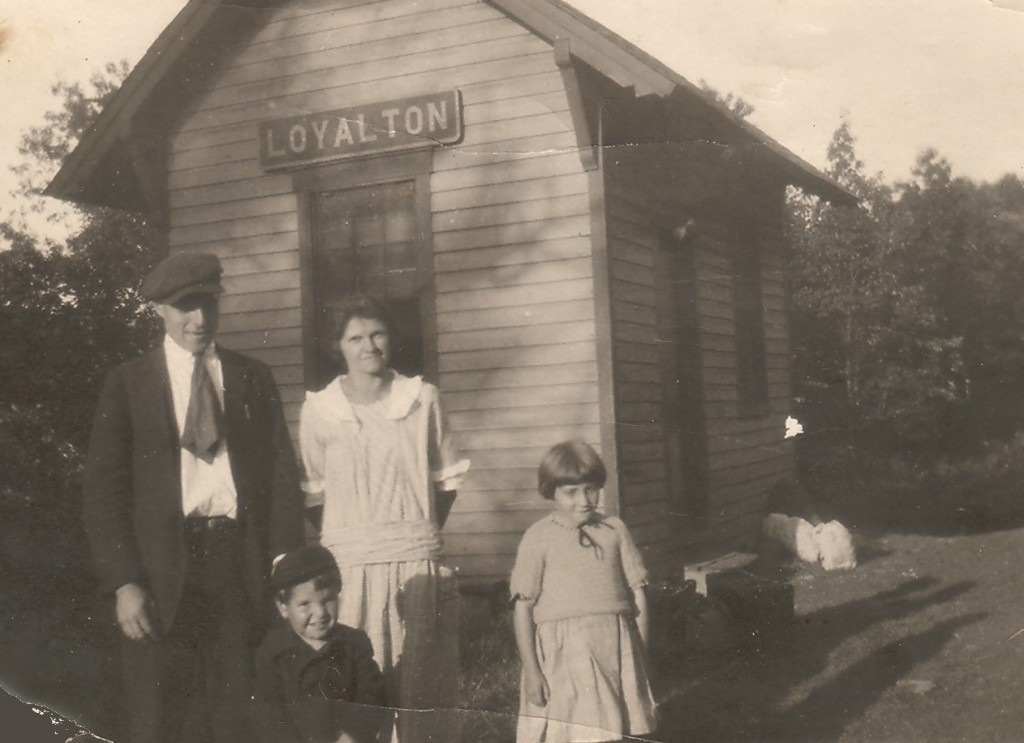
Oak Dale Station never had the commercial success of other stops on the line and remained a quiet attractive place well into the 20th century. No known Civil War era pictures exist of this rail stop and the exact date when the first station was built has not been determined. In fact, only a few pictures exist of the small station and they are from the era when it was re-named Loyalton. The station name sign was in the Pennsylvania Railroad style.
The picture below is from a family collection and has never before been published. It shows William and Helen [Hoffman] Dietrich of Specktown waiting to board the train with their two small children. It was taken in the early 1920s. Thus far it is the only known picture of passengers waiting at the station.
After the Civil War, the rail line was extended from Lykens to Williamstown and was referred to as the Summit Branch Railroad. Passenger service also was provided later from Lykens to Philadelphia by the Reading Railroad – the first eastern rail route out of the Lykens Valley area. But by 1937, passenger service on the Lykens to Millersburg line was discontinued, most likely a victim of the automobile. And by the 1970s, the ultimate indignity occurred – the tracks near the former Oak Dale Station were removed leaving an abandoned rail bed. Eventually, all the tracks were removed between Lykens and Millersburg.
Efforts in the 21st century to create a rail-trail for biking and hiking from Lykens to Millersburg were not met with complete success as some of the communities along the old line resisted. There has been no serious talk of re-establishing rail service.
Further information on Oak Dale Station and the rail line as it existed during the Civil War is being sought. Pictures are especially welcomed – of the types of rail cars that may have transported soldiers to Harrisburg and of the stations along the Lykens to Millersburg line.
At the top of this article is a picture of a section of a map on display at the The State Museum of Pennsylvania in Harrisburg, Dauphin County, Pennsylvania, “A New Map of Pennsylvania with Canals and Railroads.” The black horizontal line in the center shows the rail line from Millersburg to Lykens while a thin red line that runs vertically on the eastern shore of the Susquehanna River depicts the Northern Central Railroad.
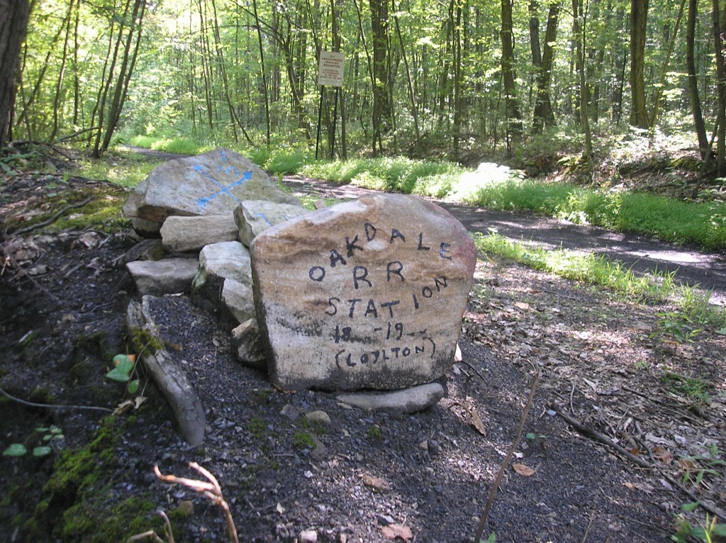
The location of the old Oak Dale Station is marked today by a crudely hand-lettered stone. It is easily accessible by traveling south from the traffic light in Loyalton to the dead end of Oak Dale Station Road.
 ;
;


Comments